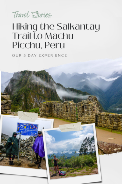
At the beginning of 2018 we hiked the Salkantay Trail to Machu Picchu. A long and scenic trail to the archaeological site of Machu Picchu in the Peruvian Sacred Valley. It’s an alternate trail to the popular Inca Trail, which is often booked up months in advance and can only be trekked guided.
Salkantay Trail is a moderate to difficult trail. With challenging mountain terrain and high elevation gains. It’s almost twice the distance as the Inca Trail. It holds historical and religious significance as a route the Incas took to get to Machu Picchu. The higher elevations were said to bring people “closer to god”.
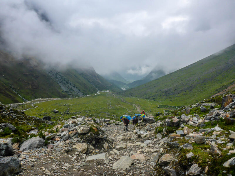
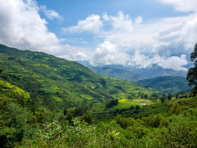
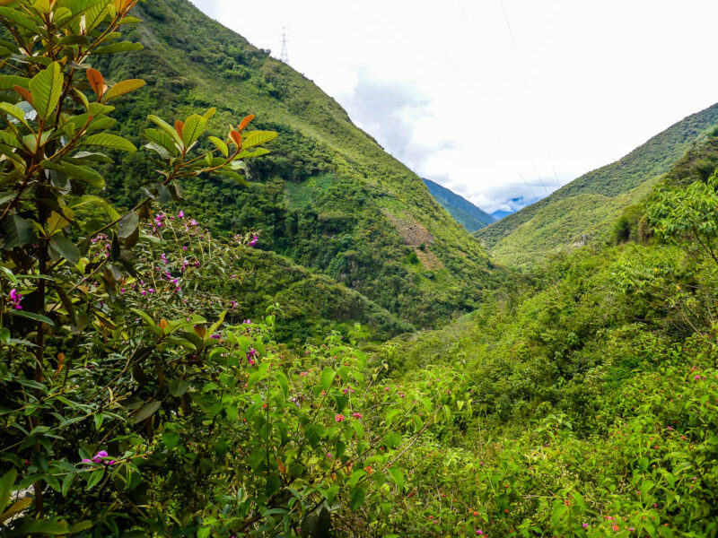
The trail is named after Salkantay Mountain. It is the twelfth-highest mountain in Peru forming part of the Peruvian Andes. The highest part of the trek is the Salkantay Pass, reaching 4,640 meters. The trail offers beautiful diverse landscapes including mountains, glaciers, and tropical Andean forests.
For more practical informaton about hiking the Salkantay Trail, check out 5 Day Trek to Machu Picchu: The Salkantay Trail Unguided.
Our Experience
When we hiked Salkantay Trail, we actually didn’t know how long the trail was. There was limited information available at the time. All the maps and signposts we saw along the way gave us different information. The official distance is 74km. We went above and beyond doing 90km. After visiting Machu Picchu we hiked back to Hidroelectrica to return to Cusco. Why did we do that instead of leaving from Aguas Caliente? Great Question. I don’t remember but assume it has something to do with cost savings.
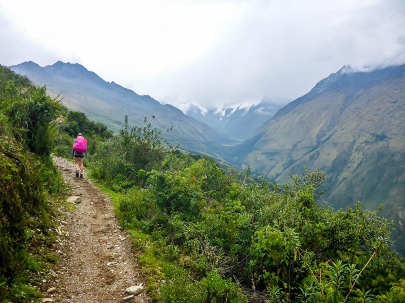
We started in the small mountain town of Mollepata, a couple hours from Cusco. After being dropped off in a mini-van, we were left to fend for ourselves for the next five days. Everything about Salkantay Trail is both gruelling and rewarding. I vividly remember how mentally and physically exhausted we were at the end of it. But at the same time, we felt accomplished and elated. It was an unforgettable adventure. One we still talk about six years later.
Day 1 – “It’s not easy and you will be eaten alive”
Mollepata to Soraypampa. 19.7km. 1,296 m elevation gail, 229m loss
We were off to an early start, catching a bus at dawn from Cusco to Mollepata. It wasn’t long before the continuous inclines, steep declines, rugged terrain, ever-changing conditions, and abundance of bugs brought us to our trek slogan: “It’s not easy and you will be pollinated and eaten alive”. We later shortened this to simply “It’s not easy,” relating it to anything and everything.
It’s possible to bypass this first part of the trek and drive directly to Soraypampa. But since we never do anything easy, hence the slogan, we wanted to complete Salkantay Trail in its entirety.
Off to a Great Start
The weather was decent to begin with, something we didn’t expect given the time of year. As we climbed through the sub-jungle trail we became increasingly hot and sweaty.
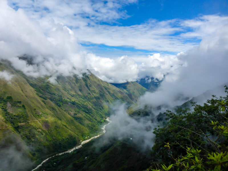
The track cut its way through luscious farm land before eventually and mercifully continuing on a dirt road. We got a small glimpse of tomorrow’s battle, the ominous looking Mount Salkantay standing at an impressive 6,271m (20,574ft). Our picturesque mountain view didn’t last long before clouds rolled in unleashing deafening booms of thunder and lightning.
Camp Life
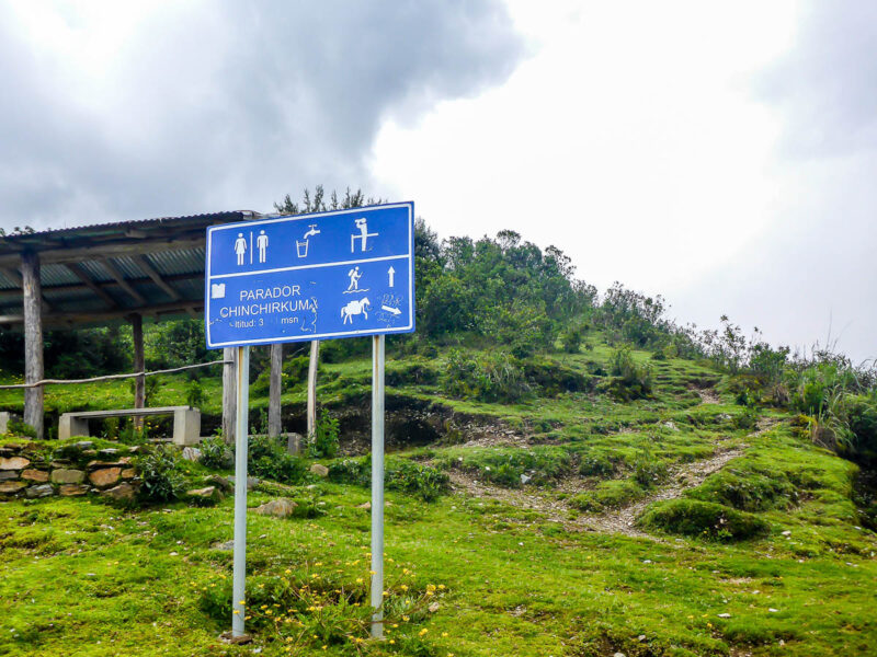
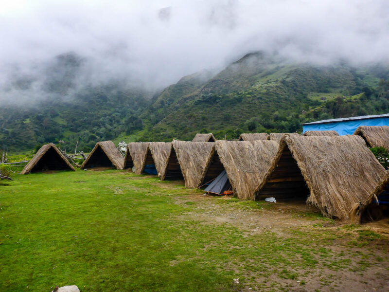
We arrived at our home for the night after 8 hours of ups and downs. Soraypampa is catered to trekkers of Salkantay Trail and has very few permanent inhabitants. It is populated with campsites, a hotel, amenities, and supplies to help you prepare for the next few days.
Prepared to camp the entire trip, we chose the paid campsite with protection from the elements. We paid a minimal fee to pitch our tent on a wooden platform in a triangular hut.
Little did we know, day one was the driest we would be for days.
Day 2 – “When elements attack”
Soraypampa to Chaullay via Salkantay Pass, 18.9km, 771m incline and 1,807m decline.
Our second day was off to a purposefully slower start. We slept in and enjoyed a peaceful morning waiting for the guided tours to clear out before making our way. After a simple oatmeal breakfast, we hit the trail at 9am without a single tour group in sight.
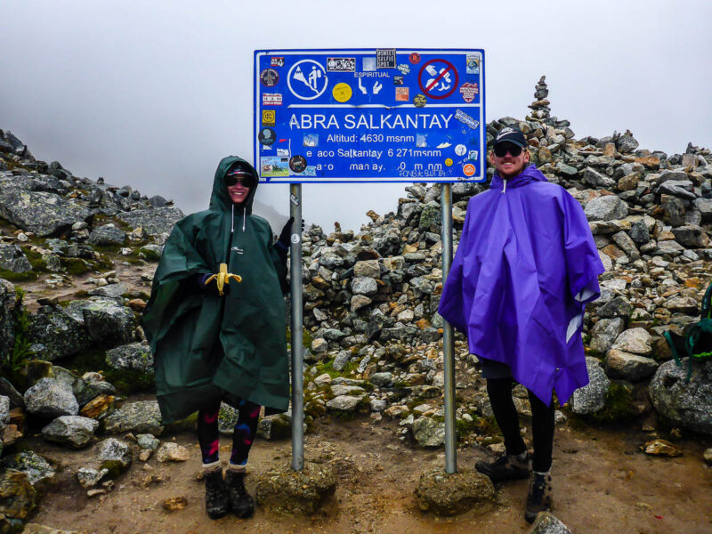
We knew the second day would be challenging. Our biggest obstacle, or so we thought, was traversing the Salkantay Pass at 4,630m (15,190ft). What we didn’t expect was the weather being as horrendous as it was.
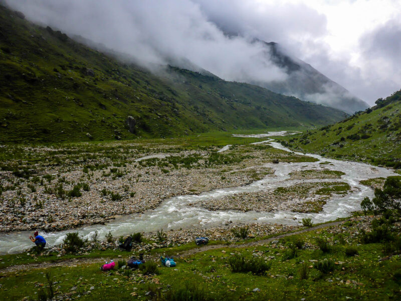
The route leaving Soraypampa was unlike anything we had seen. We crossed farmland and overflowing rivers with lush greenery all around us. Wild horses and livestock roamed free. It looked like we had stepped back hundreds of years in time.
The Climb
The ascent to Salkantay Pass was a tough, unrelenting journey. It was an unforgiving straight up 771m climb. As we climbed up and over 4,000m light rain became heavy. Eventually leading to fog and hail at the summit. We approached the pass at a snail’s pace. With every step we took the air became increasingly thinner. 4,630m (15,190ft) was the highest we’d ever been on a mountain.
After a three hour climb we finally made it to the highest point on the entire trek. The cloud lifted slightly at the top, just for a moment, to reveal some of Mount Salkantay’s huge glaciers and snow capped peaks.
The second part of the day was never ending hell. We went on a near 2,000m descent towards our next stop, the seemingly mystical and far reaching campsite of Chaullay. The rains didn’t stop for hours. We were soaked from head to toe. Our rain jackets and ponchos were no match for the day’s downpours.
Where Did the Trail Go?
Where once was a walking path was a combination of rivers and streams to wade through. There were giant cascading waterfalls on both sides of the valley. It was absolutely stunning. However, hiking in the wet season is difficult.
Around 4pm the rain finally ceased and we got some blistering sunshine for the last part of our day. After taking a quick glimpse at the map we thought we were close to the campsite. We were wrong. Soon after the sun came, it disappeared again and in its place was a thick and dense fog leading to 0 visibility. With this and the fading light we feared not actually being able to reach camp.
At close to 6pm we found our home in the fog and set up for the night. This long unforgiving day made us question our love for this outdoor activity.
Day 3 – “Not your typical rest day”
Chaullay to Lucmabamba – 22km, 482m incline & 1,324m decline
The day that never ended and was full of lies from all sources. We may have gotten lost once or twice. Following signs and maps that were seemingly both outdated and inaccurate. We used a combination of the trail and local roads.
Day three started off well. In good faith with happy hearts. Full of energy and enthusiasm for what was to be a “rest day”. A casual five or six hours. “Easy day”, they say.
In reality, it took us 7.5 hours. Filled with confusing signs, unclear maps, inaccurate directions, and misunderstood trail markings and distances. Combine that with several steep climbs and descents and you have two unhappy campers.
Unchartered Territory
The first part of the trail was through the jungle. After leaving Chaullay, we ventured along the riverbend. There was a series of steep inclines and declines before we crossed a bridge joining with a dirt road on the other side.
We were unable to follow the normal track due to a huge landslide. Luckily, we had been waved over by a local who warned us the trail was impassable. From there, the dirt road was never-ending.
We tried to follow our map and estimate where we were and how far we had to go, but were unsuccessful. Our map’s depiction of Salkantay Trail was out of date and incredibly inaccurate. We found this out the hard way, when we learned from locals that we were nowhere near our planned nightly destination. By this point we had already been walking for six hours. Six hours of tough terrain, might I add. A far cry from the relaxing stroll we all had been promised. It felt like a miracle when we finally arrived at our camp for the night.
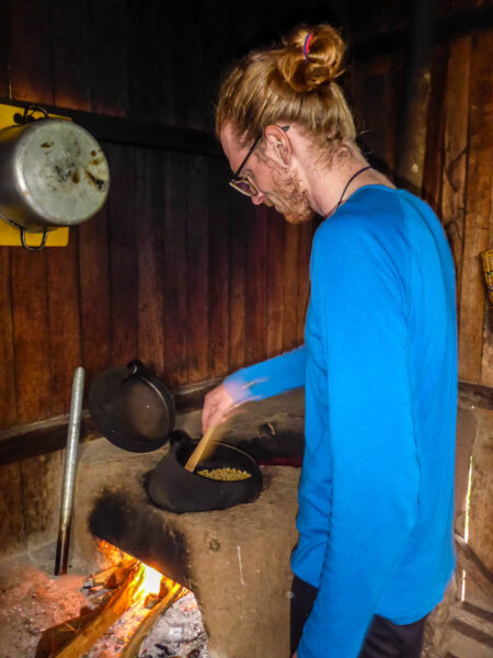
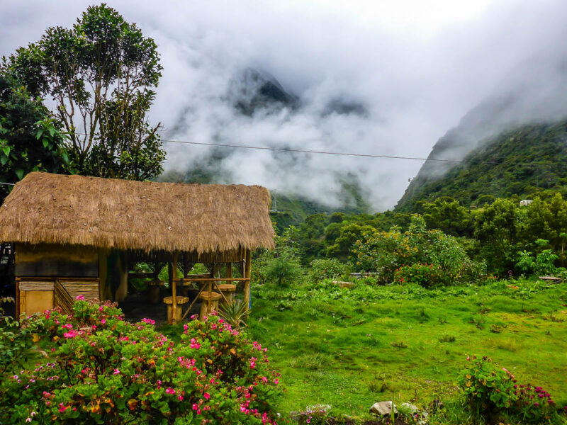
Viamonte Coffee Plantation
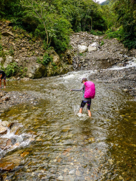
Despite the setbacks, day three had amazing high points. We saw beautiful lush dense jungle flora and fauna and colorful butterflies in all shapes and sizes. Our feet got wet taking our shoes to cross a waterfall turned river crossing in the middle of a road. We hurried across sketchy bridges, explored quaint villages, and even had our fair share of sunshine.
To top it all off, we stayed at a quaint authentic coffee plantation. Viamonte Coffee Plantation in Lucmabamba is the perfect ending to a chaotic day. We were treated to a private plantation tour. We tried a variety of coffees, coffee liqueurs, and honey made only by bees who pollinate the coffee berry trees. In addition to learning about the plantation and the process, we tried it out for ourselves by hand-roasting our own beans.
The onsite campsite, which we had to ourselves, was in a picture perfect setting overlooking the valley. The day may have been tough, but the evening made up for all of it.
Day 4 – “Up and down, and everywhere in between”
Lucmabamba to Aguas Calientes via Hidroelectrica – 21km, 860m incline & 810m decline.
The fourth day was challenging for reasons neither of us expected or were prepared for.
It was a day of highs and lows, both figuratively and literally. Starting off the day was a 700 climb to the recently discovered Inca ruins of Llactapata. It took us about three hours to work our way up through the dense and humid Cloud Forest before reaching the high point. From here we took a long awaited lunch break, reflecting on our accomplishments thus far.
Destination in Sight
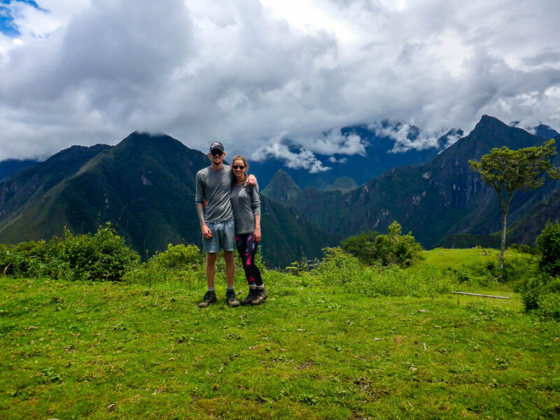
It was here we got our first clear view of Machu Picchu. Even from miles away, it was a remarkable sight. With the tough mountainous terrain and thick lush greenery, it’s amazing how the Incas managed to build a city in a place so remote.
After some quiet reflections, the next thought was pure dread. After climbing all this way, the only way through was right back down. We had to descend all the way down to the river bed before climbing back up to Machu Picchu a day later.
The track was relentless.
The Only Way Through is Down
Our descent to Hidroelectrica took hours. The 810m drop on heavy legs was painfully tough. Even though a couple tour groups had gone ahead of us, the trail was still overrun with spiderwebs and overgrown bush.
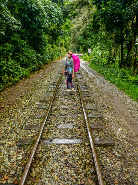
Once we had reached the river we had another 11km to hike over train tracks. This was more difficult than we bargained for. Even though it was flat, the trail was on odd-sized stones and rocks, making it difficult to know where to step and keep your balance.
Having reached Hidroelectrica, we were greeted by masses of tourists. More people in one place than we had seen in the four days combined. The majority of people had either taken the train or bus from Cusco.
Train Trails
The last leg of our journey kept up with the day’s theme. It was a long, uneven, unstable, and tiring time. The rain started falling again, we were back in ponchos, and following the train tracks to the town of Aguas Calientes.
Sufficiently exhausted, sore, and drenched, we set up camp for the night at the municipal campground just a few hundred meters from the Machu Picchu gates. We set ourselves up with a 3am wake up call in order to climb the 400m to the famous archaeological site.
Day 5 – “This is The End”
Aguas Calientes to Machu Picchu (Huayna Picchu) to Hidroelectrica – 13km, 851m incline & 803m decline.
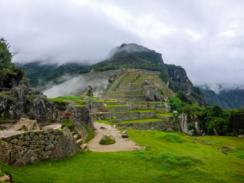
After 82km and 4 days on the Salkantay Trail we finally reached our end point, Machu Picchu.
Unfortunately our experience wasn’t as perfect as we had hoped. The weather laid waste to our plans. We only managed to spend two hours at the site before being forced back down the mountain by the rain. And to top it off, proposal plans were thwarted from said rain. (Who’s proposal plans, you may be asking? Ours. Our proposal plans. Don’t worry dear reader, after a second failed attempt the proposal was a success).
Final Destination
We woke up at 4am, had a quick breakfast and made our way to the base of the “Stairway to Heaven”. The stairway is a steep set of stairs intersecting the road leading to the gates of Machu Picchu. We practically ran up the stairs. Partly because we were excited. Partly because we were exhausted. And partly because we wanted to get in there before the storm. It took us about 40 minutes to make our way to the top just before 6am.
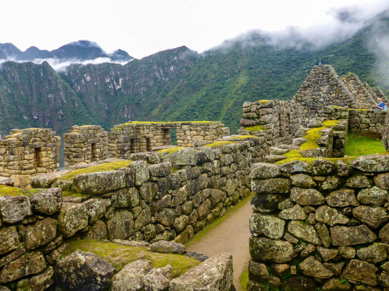
Upon entering the site, we were amazed. Over 70% of the site has been restored to near perfect conditions giving a true reflection of Inca life. We had perfect weather for the first hour before being treated once again to a heavy downpour of rain.
Climbing Higher
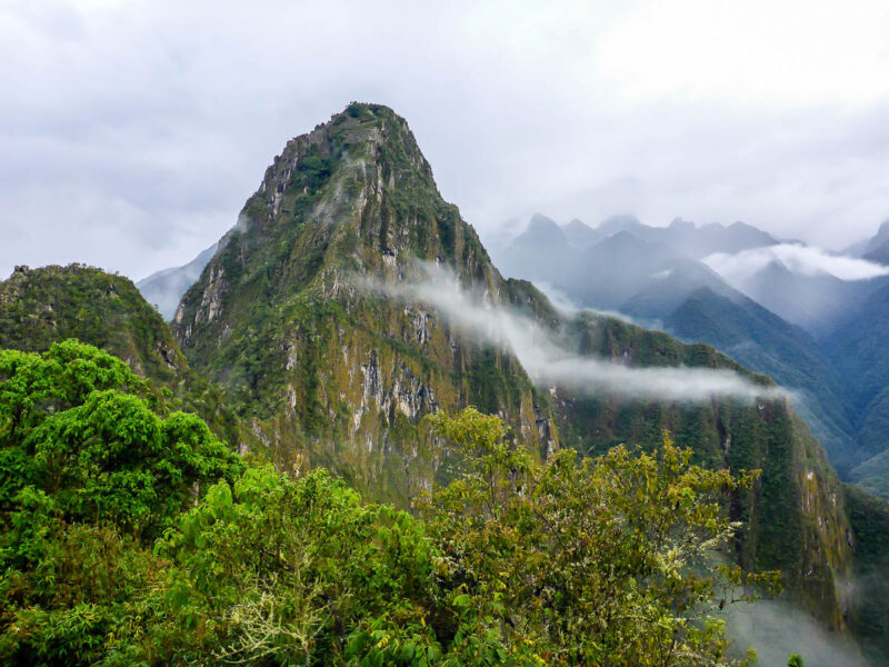
In addition to Machu Picchu, we had tickets to climb Huayna Picchu. At 2,693m, Huayna Picchu is the highest point of the archaeological site and 260m higher than Machu Picchu.
In clear conditions we would have had unrivaled views of the site and entire surrounding valley. Unfortunately, those are conditions we did not have. It started raining just before we started climbing at 7am and didn’t stop for another four hours.
At the top of Huayna Picchu we didn’t see anything. The cloud covered everything. We were wet, exhausted, and totally miserable. After descending back to Machu Picchu we took the collective decision to abandon our day. A gut wrenching feeling after all the effort we had put in prior to this point.
Not the Happy Ever After We Hoped For
The weather caused complete havoc and streams of people were heading for the exit just like us. We only explored about 20% of the site.
The weather can’t be helped and although this Machu Picchu experience wasn’t what it could have been. It was a stark contrast to when I visited in June 2010 and experienced perfect conditions. The rainy season won this round. We will return in the future to make up for it.
From the terrain, the weather, the elevation gains and losses, and the climate. The breathtaking views, company we kept, locals we met along the way. Salkantay Trail tested our patience, physical endurance, and mental strength.